CAA Compliance & Safety
Above and Beyond Drone Services operates as a CAA-approved drone operator, holding a GVC qualification and the appropriate UK CAA Operational Authorisation. All flight operations are conducted in full compliance with current UK aviation regulations, including airspace restrictions, risk assessments, and operational limitations.
Safety is at the core of every mission. Detailed pre-flight planning is undertaken for each project, including site surveys, airspace checks, weather assessments, and client-specific risk mitigation. Our operations follow documented procedures aligned with CAA requirements, ensuring safe, controlled, and professional drone deployment at all times.
We carry comprehensive public liability insurance and maintain strict maintenance and operational standards across all equipment. This approach allows us to operate confidently on commercial, industrial, and sensitive sites, providing clients with complete assurance of regulatory compliance and operational professionalism.
LiDAR & Photogrammetry Survey Services
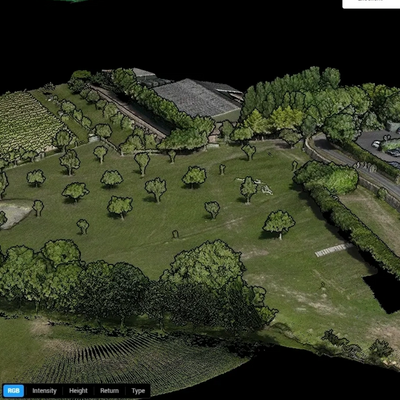
We provide professional drone-based LiDAR and photogrammetry survey services designed to deliver accurate, repeatable, and actionable data for a wide range of applications. Using advanced drone platforms and precise data-capture workflows, we support projects that require reliable spatial information and high-resolution outputs.
Our LiDAR and photogrammetry services are suitable for construction, land development, infrastructure, environmental monitoring, and asset management. Typical deliverables include point clouds, orthomosaics, digital surface models (DSM), digital terrain models (DTM), and 3D reconstructions, tailored to project requirements.
By combining CAA-approved flight operations with proven survey methodologies, we ensure data is captured efficiently, safely, and to a consistently high standard. Our drone-based approach reduces site disruption while providing a cost-effective alternative to traditional survey methods.
Commercial & Public Sector Capability
Above and Beyond Drone Services works with commercial organisations, construction firms, surveyors, and public sector clients, delivering compliant and dependable aerial services for both one-off projects and long-term programmes.
We understand the requirements of procurement-led environments, including method statements, risk assessments, insurance documentation, and compliance verification. Our experience operating on active construction sites and controlled locations allows us to integrate smoothly with existing site procedures and health and safety frameworks.
Whether supporting construction progress monitoring, infrastructure inspection, survey data capture, or planning and development projects, we provide professional, CAA-compliant drone services that meet the expectations of councils, developers, and engineering teams.
Custom Services
Need something unique? We offer custom drone photography and videography services to meet your specific needs. Contact us today to discuss your project and get a quote.